TROPICAL REVOLVING STORM ( TRS)
The name "TRS," or tropical revolving storm, is well known to all sea farers. A TRS is a strong revolving depression, or area of low pressure at the surface, that forms over tropical waters. It is made up of a revolving mass of hot, humid air that produces thunderstorms with powerful winds, torrential rain, high waves, destructive storm surge, etc. It involves conventional forces, which often extend from the depression's surface to the tropopause.
The following are some crucial traits of a Tropical Revolving Storm (TRS):
They appear to be smaller than temperate depressions in size.
They develop close to an unstable zone known as the Inter Tropical Convergence Zone.
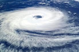
Nearly circular isobars are present.
Normally occurs in Equatorials regions namely 5 to 15 Degrees North or South Latitudes.
The rising warm air from the seas condenses the clouds while releasing massive amounts of heat. This combination of heat and moisture leads to thunderstorms.
The direction of the TRS in the Northern Hemisphere is initially Westerly then North Westerly and South Westerly in the Southern Hemisphere after which they usually recurve and head towards Northeast in the Northern Hemisphere and to Southeast in the Southern Hemisphere. There are two sides to a TRS namely The dangerous semi-circle and the navigable semi-circle. The wind in the Dangerous semi circle moves in the same direction as the TRS and therefore very strong winds will be experienced. In the Navigable semi-circle the wind and sea state will be less severe and also will push the Vessel away from the TRS.
The size of the TRS is typically around 200 to 500 Km in diameter and bring in a lot of destruction including coastal flooding.
The Pacific Ocean generates the largest number of tropical storms and cyclones. After the
Pacific, Indian Ocean followed by Atlantic Ocean sees a lot of storms. In the North and South Pacific oceans these storms are referred to as ‘Hurricanes’. In Bay of Bengal, Arabian Sea and South Indian Ocean these are called ‘Cyclones’.
Rhese storms move at a speed of 16-24 km/h but can travel up to 65 km/h. The rotation/spin of the Cyclone is caused by a phenomenon called the Coriolis Effect.
For a watch keeper at Sea on the Bridge, the following changes in the weather shall be an indicator for the presence of a TRS:
An appreciable change in the direction and strength of the wind
A long swell originating from the centre of the TRS
As the storm approaches, large amounts of Cirrus clouds formation followed Alto Stratus and then broken Cumulus
The corrected Barometer reading falls 3 to 5 hpa below the mean for that time of the year( as per the Climatic Atlas).
TRS avoiding action to be taken as follows:
In the Northern Hemisphere:
If the vessel is located in the Dangerous semi circle, put the wind on the starboard bow and alter course to starboard as the wind veers.
If located in the Navigable semi-circle put the wind on the starboard quarter and alter course to port as the wind backs.
In the Southern Hemisphere:
If the vessel is located in the Dangerous semi circle, put the wind on the port bow and alter course to port as the wind backs.
If located in the Navigable semi-circle put the wind on the port quarter and alter course to starboard as the wind veers.
Ship Weather Routing Services are based at shore side locations and are made up of teams of experienced seafarers/meteorologists with access to latest analysis and weather forecast charts, weather and storm warnings, ice formation and satellite pictures continuously updating the seafarers. They provide the safest and most efficient routes for ships to follow that use their services thereby avoiding the worst situations at sea.
Also the warnings are received through Enhanced Group Calling (EGC) messages the position of the TRS can be successfully plotted and avoiding action taken accordingly.

Capt. Raman Jayaram
Vice Principal
Sri Chakra Maritime College, Puducherry